SAN ANTONIO — A Winter Storm Warning has expired for Bexar County and the surrounding region, but residents are still urged to take precautions at home and on the roads as freezing conditions persist.
Freezing rain was expected to continue to accumulate at least through mid-morning Monday, but the potential for hard freezes and frigid wind chills are expected to continue until Wednesday.
How long will cold temperatures remain?
Bundle up, San Antonians! The arctic blast is sticking around for a while!
Temperatures dropped from into the low 30s Sunday and then into the 20s overnight into Monday morning. Temperatures will remain in the 20s and 30s until Tuesday afternoon, so you'll need to be ready for the cold and careful on the roads.
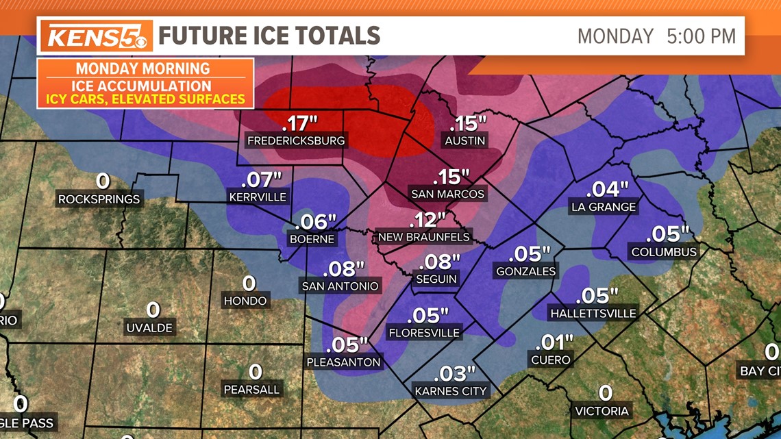
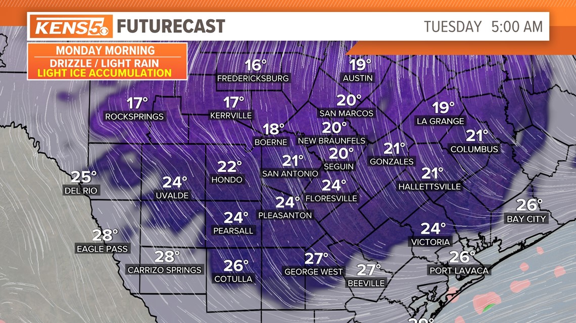
Monday - MLK Day: (High 35 and and Low 25): On Monday morning, San Antonians woke up to temperatures in the 20s with cloudy conditions and freezing rain. There was some ice accumulation on surfaces such as cars, outdoor stairs, patios and even some bridges.
Most of Bexar County saw a moderate level of driving conditions, meaning there was some ice on elevated surfaces, such as bridges and even some tree limbs.
Most of the heavy icy conditions stayed to the east of Bexar County and toward New Braunfels and Austin. Areas west of Bexar County had very little impact for ice except for some slick roads and sidewalks.
Those south of Bexar County saw only a few icy spots, ice on cars and light rain activity. Overnight temperatures will drop back down in the low 20s and even the teens. Prepare for another hard freeze overnight into Tuesday morning.

Tuesday: (High 37 and Low 18): Tuesday will be one of the coldest days of the arctic blast, with temperatures waking up in the possible teens and wind chill temperatures in single-digits in San Antonio. In Hill Country communities, the wind-chill value is expected to drop into the negatives.

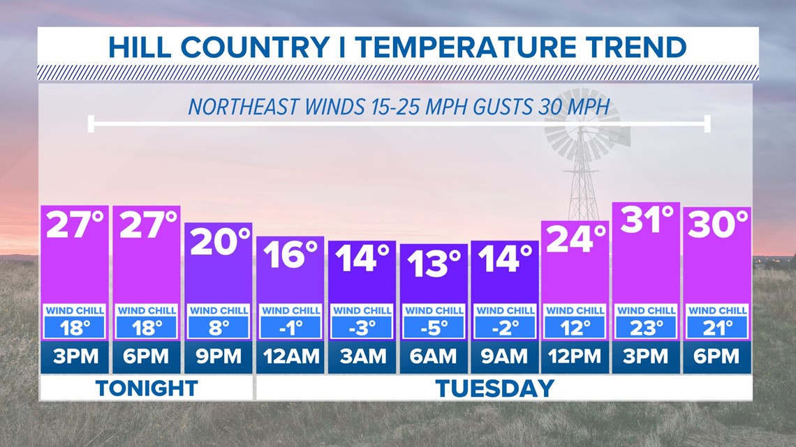

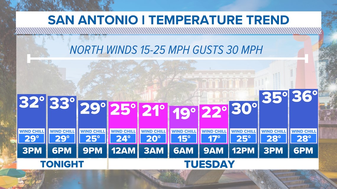
The good news is the sun will come out eventually, warming temperatures to near 40, which will feel like spring after recent days of frigid cold mornings. Since the winds will still be blowing north at 20 to 30 mph, wind-chill values could feel like temperatures are at 5 degrees! This means you will want to bundle up with the gloves and hats to keep warm if planning to go outdoors.
This is another day when you will want to prepare for a hard freeze as temperatures will once again drop in the teens overnight.

Wednesday (High 45 and Low 18): This should be the last day of extreme cold weather. While morning temps will still begin in the teens, the afternoon will warm up to the upper 40s in San Antonio. Temperatures should not drop below-freezing on this night.
By Thursday San Antonians will see a quick warm-up with high temperatures in the upper 60s.