
SAN ANTONIO — Hurricane Laura has downgraded to a tropical storm as it continues to move north through Louisiana into Arkansas with strong winds and flooding rainfall.
Damage assessment in southeast Texas and the southern portion of Louisiana has begun. Laura made landfall around 1 a.m. Thursday as a Category 4 hurricane, making it the fifth strongest hurricane to ever make landfall in the United States.
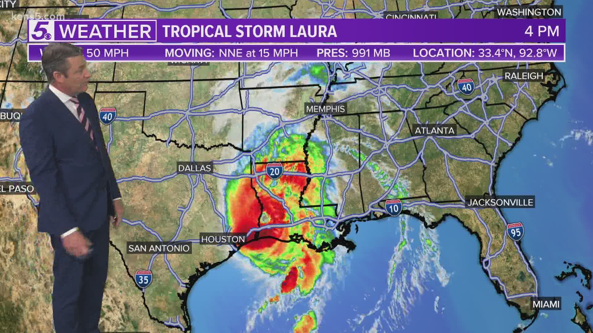
4:30 p.m. Update
Laura is now a tropical storm, maximum sustained winds of 50 miles per hour. The storm is moving north-northeast at about 15 miles per hour into Arkansas, according to the latest update from the National Hurricane Center.
Weather Chief Bill Taylor has a 4:15 p.m. update on Laura's track:
3:00 p.m. Update
Louisiana Governor John Bel Edwards said state officials now know of four deaths tied to Hurricane Laura, including a 14-year-old girl and a 68-year-old man.
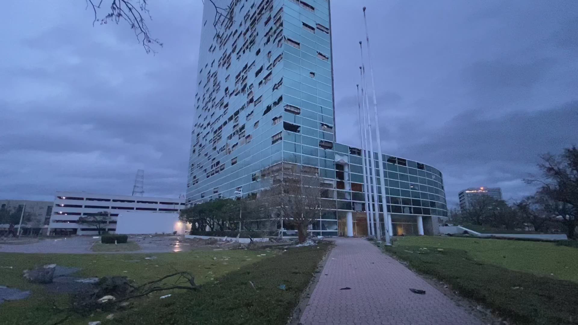
Louisiana took the brunt of the damage when the Category 4 system barreled over Lake Charles, an industrial and casino city of 80,000 people. Laura's powerful gusts blew out windows in tall buildings and tossed around glass and debris. Police spotted a floating casino that came unmoored and hit a bridge.
Meanwhile in Texas specifically, Gov. Greg Abbott reports that there has been minimal loss of life due to Hurricane Laura and 160,000 Texans are currently without power.
"It could've been far worse," Abbott said local officials told him as he toured the damage Thursday, noting they were bracing for a storm surge as large as 10 feet and it ended up being about 3 feet.
1:30 p.m. Update
According to Texas Tribune, Laura has weakened to a tropical storm as it tracks northeast through northern Louisiana, and tens of thousands of Texans are without power. Still, evacuation orders in parts of the coastal bend are being lifted.
"Jefferson County’s evacuation order will expire at 10 a.m. Jefferson County Judge Jeff Branick said Wednesday he hoped residents would be able to return after a couple of days, the Beaumont Enterprise reported. But the timeline decreased after Hurricane Laura veered away from the area. There were no reports of major emergencies in Jefferson, Orange and Hardin counties, the newspaper added, although tens of thousands of residents are out of power.
"Galveston County officials also announced that residents are welcome to return after the area saw only minimal damage from the storm."
12 p.m. Update
The storm is following a northwestern route and currently has maximum sustained winds of 70 mph.
High water levels persist along portions of the Gulf Coast.
11 a.m. Update
Laura has weakened to a Category 1 storm.
The storm continues to move through Louisiana with maximum sustained winds of 75 mph.
Widespread flash flooding along small streams, urban areas, and roadways will continue through portions of Louisiana, Mississippi, and Arkansas.
Dangerous storm surge will result in elevated water levels for the next few hours along the Gulf Coast.
At this time, three people have died from falling trees in southwest Louisiana as Laura made landfall.
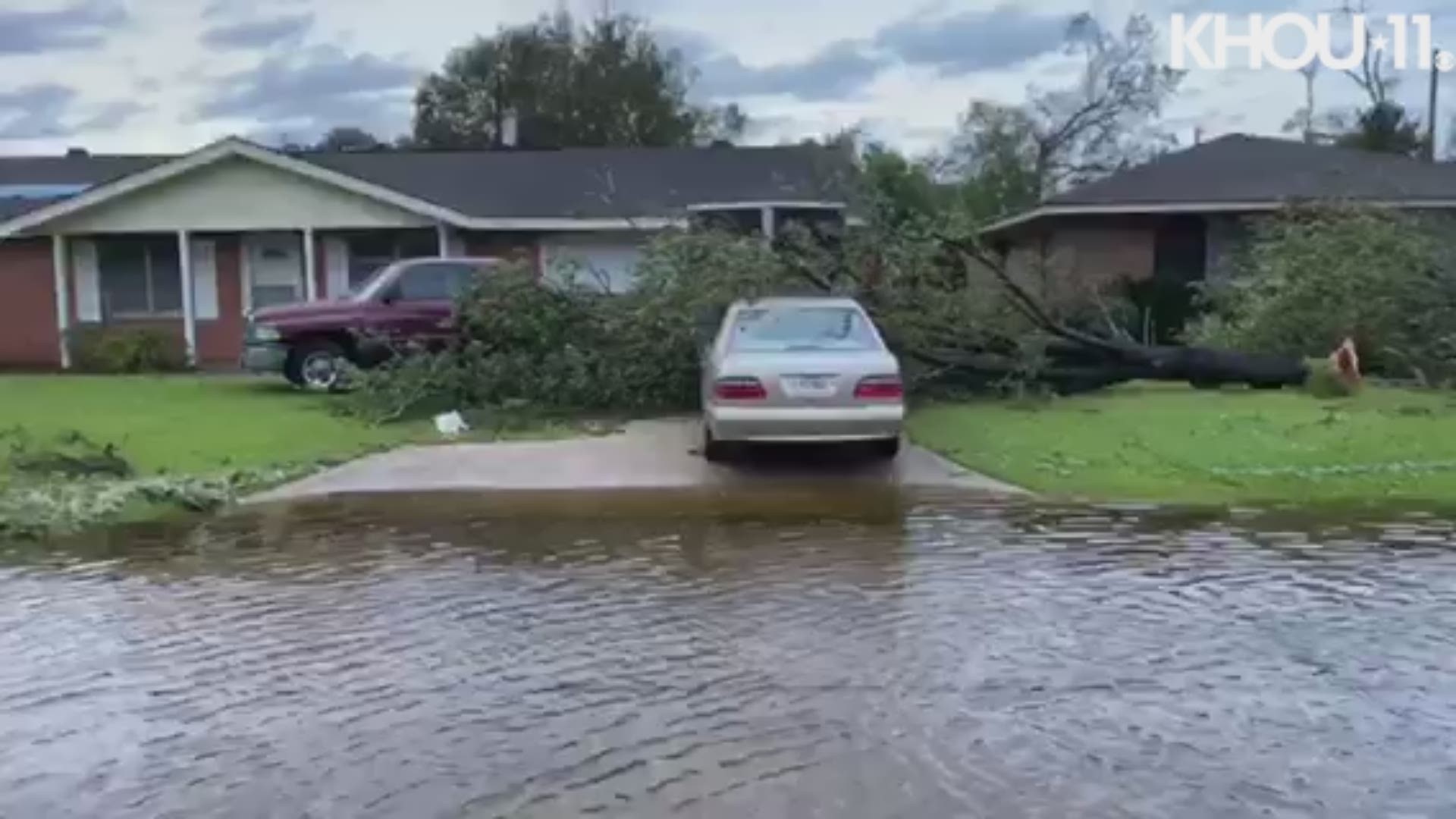
The following video shows damage and flooding in Orange County, Texas after Laura made its way through.
10 a.m. Update
KENS 5 Meteorologist Paul Mireles gave a 10:15 a.m. update on the track of Hurricane Laura and where it fits into the historical hurricane data.
9 a.m. Update
Maximum sustained winds have dropped down to 85 mph, as Hurricane Laura moves north through Louisiana at 15 mph.
Flooding rainfalls continue to spread inland over the western and central parts of the state.
8 a.m. Update
Hurricane Laura remains a Category 2 storm for the time being.
The storm continues to move north at 15 mph with maximum sustained winds of 100 mph. A storm surge along much of the Lousiana coastline continues to be a major threat.
More than 7 hours since the storm made landfall, we're getting an early look at the trail of destruction Laura has left behind in her wake.
The Texas Tribune reports that evacuation orders in some parts of Texas will be lifted Thursday morning after officials there said residents can expect to make their way back home sooner than expected.
7 a.m. Update
Laura, a Category 2 storm, continues to move north at 15 mph with maximum sustained winds of 100 mph.
Damaging winds, flooding, and heavy rainfall continue through western and central Louisiana. A life-threatening storm surge continues among much of the Louisiana coastline.
In southeast Texas where KENS 5 reporter Jaleesa Irizarry is, the skies have lightened a bit as morning comes.
And here's a look at storm coverage in Port Arthur:
6 a.m. Update
Hurricane Laura remains a Category 2 storm for the time being. Damaging winds and heavy rainfall continue as the storm moves north through Lousiana.
Here's a look at some of the damage in downtown Lake Charles:

5 a.m. Update
Hurricane Laura downgraded to a Category 2 with maximum sustained winds of 110 mph. Laura made landfall as a Category 4 overnight.
Laura is the fifth strongest hurricane to ever make landfall in the United States.
KENS 5 Meteorologist Paul Mireles explained that storms weaken as they move inland due to the friction of the land. Additionally, the storm loses its source as it moves further away from the ocean.
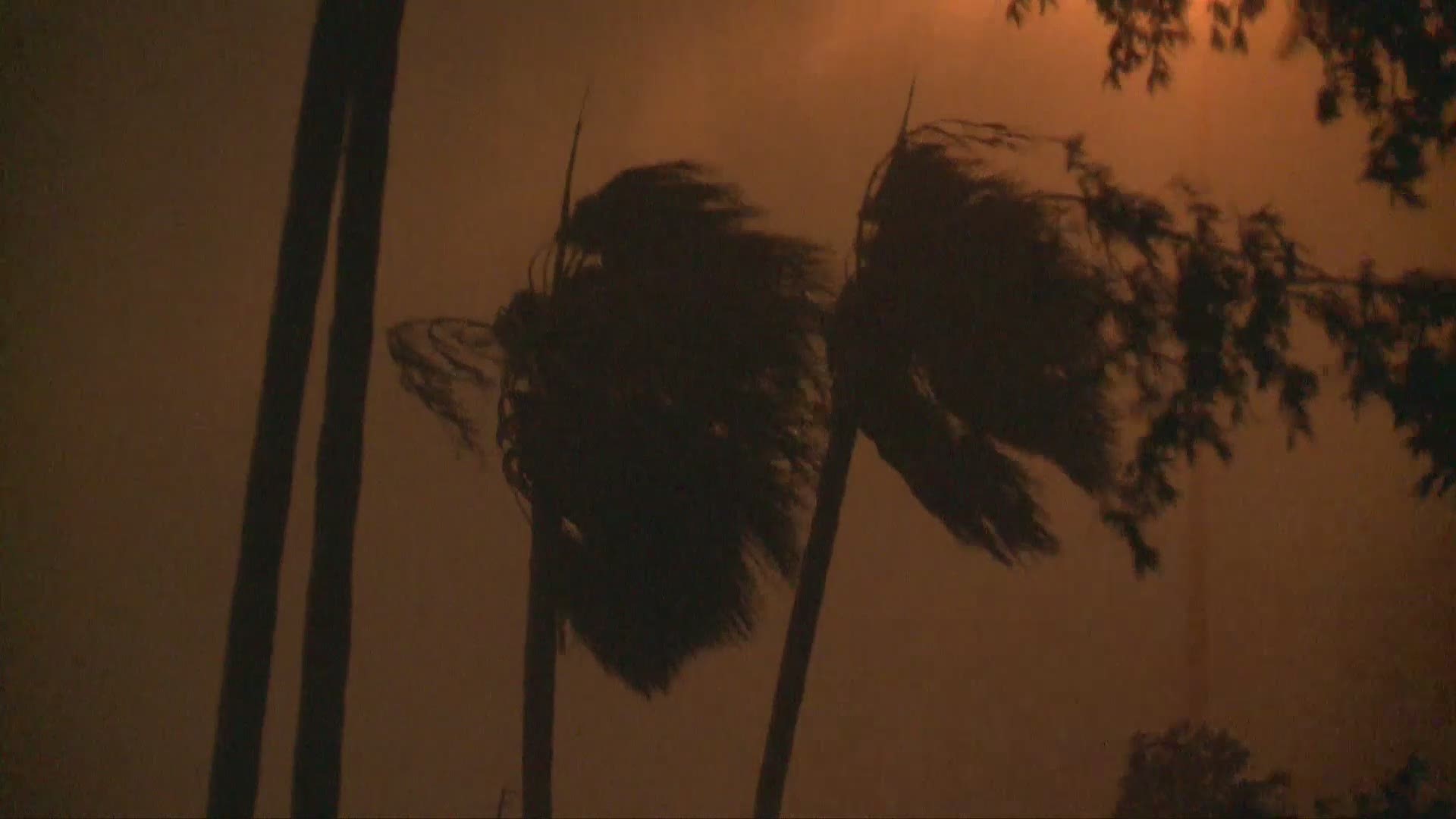
Take a look at this footage captured in Beaumont overnight:
4 a.m. Update
Catastrophic storm surge, extreme winds, and flash flooding continue in portions of Louisiana as Hurricane Laura continues to move inland. The Hurricane, which made landfall as a Category 4 has now been weakened to a Category 3.
At this time, Laura is moving north at 15mph across southwest Lousiana and is projected to take a northeastern path as it moves up through Louisana and Arkansas and then into Tennessee and Kentucky.
Maximum sustained winds are 120 mph. Hurricane-force winds are expected to continue this morning.
3 a.m. Update
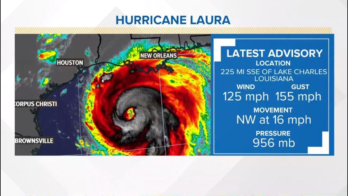
Hurricane Laura continues to move north across southwest Louisiana and southeast Texas with maximum sustained winds of 130 mph. The eye of the storm, as of about 3 a.m. Thursday, was continuing to move inland about 15 miles northwest of Lake Charles, Louisiana, according to the National Hurricane Center.
Meteorologists reminded anyone in the path of the storm to remain in shelter, as the hurricane will continue to affect the entire coastal region on southwestern Louisiana and southeastern Texas for several hours. "Treat these imminent extreme winds as if a tornado was approaching and move immediately to the safe room in your shelter. Take action now to protect your life!"
2 a.m. Update
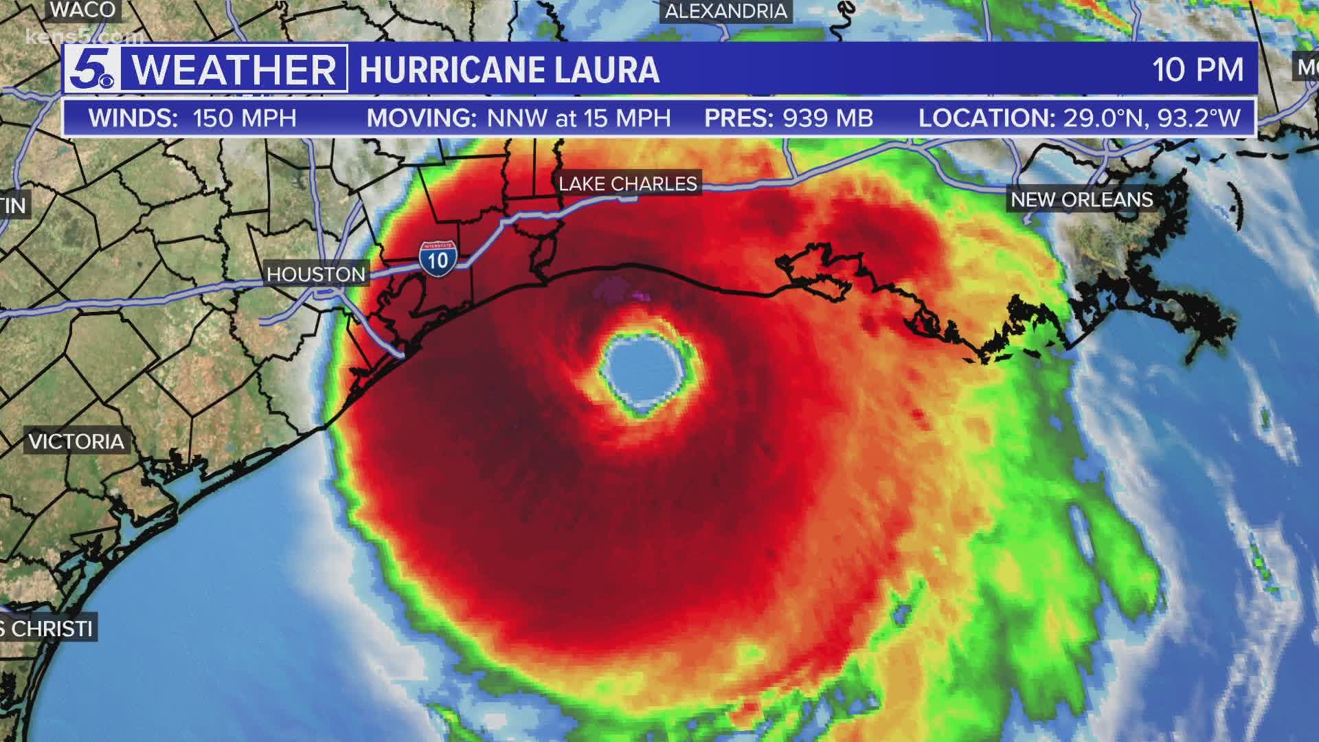
Hurricane Laura continues to churn across southwest Louisiana and southeast Texas with maximum sustained winds of 150 mph. The eye of the storm, as of about 2 a.m. Thursday, was continuing to move inland just south of Lake Charles, Louisiana, with extreme winds and flash flooding expected, according to the National Hurricane Center.
1 a.m. Update
Hurricane Laura continues to churn at max sustained winds of 150 mph as it moves through communities in southwest Louisiana and southeast Texas. The National Hurricane Center says a "catastrophic storm surge" is expected for the region, along with flash flooding and extreme winds. Rainfall of 10 to 15 inches is expected in some areas.
12 a.m. Update
Hurricane Laura has hit land. With sustained winds of 150 mph, the Category 4 storm made landfall in Cameron, Louisiana, just after midnight early Thursday morning, about 70 miles east of Beaumont, Texas.
Laura brings with it what the National Hurricane Center is calling a catastrophic storm surge that will result in flash flooding for communities in southeast Texas and southwest Louisiana.
The storm, which the hurricane center calls "extremely dangerous," has had sustained winds around 150 mph for several hours. Laura is expected to weaken as the storm moves over land.
The hurricane is expected to bring with it a deadly storm surge, and rescuers will not be able to reach those who choose to not evacuate from areas like Port Arthur, state and county leaders warned . There is "little time left to protect life and property" as the Category 4 storm heads toward the Texas-Louisiana coast according to the National Hurricane Center.
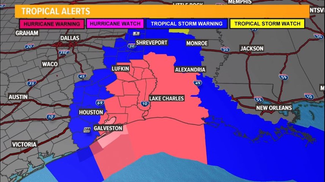
Hurricane Warnings are now posted from San Luis Pass, Texas to Intracoastal City, Louisiana.

10 p.m. Update
Here's our live coverage from the Wednesday 10 p.m. edition of KENS 5 Eyewitness News:
With warm water and favorable environmental conditions, Laura is a major hurricane, a category 4 storm. The forecast track takes Laura toward the northwestern portion of the Gulf of Mexico. There is a possibility it will strengthen even further to a Category 5 hurricane before making landfall.

Storm surge is among the worst of the dangers followed by the wind. There will be rain, but this will not be a Harvey-like flooding event.
Galveston can still expect about a five-foot storm surge (well within the limits of the seawall) while closer to Beaumont and into Lake Charles there will be about a 10 foot storm surge:

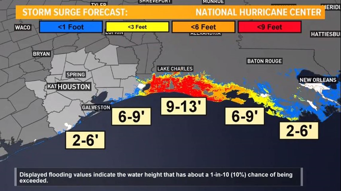
A surge could penetrate up to 30 miles inland from the southwest Louisiana coastline and far southeastern Texas.
Hurricane-force winds are expected Wednesday night in the warning area from San Luis Pass to west of Morgan City, Louisiana. The strongest winds near the eye wall will occur somewhere in that area.
Damaging wind and gusts are expected to spread well inland into parts of eastern Texas and western Louisiana early Thursday.
There's also the possibility of widespread flash flooding along small streams and roadways in far east Texas, Louisiana and Arkansas.
The hurricane will not linger and should be cleared of the landfall area after about 12 hours.
Here's live coverage of the storm from our sister station KBMT in Beaumont, Texas: