

Central America is facing a humanitarian crisis following Hurricane Eta's deadly blow. Millions are enduring dangerous conditions in the storm's wake -- with concerns over waterborne diseases and COVID-19 complicating recovery. And the situation could become even more dire. Forecasters are warning that a brewing tropical system in the Caribbean may strengthen enough to become a hurricane before it takes aim on the reeling nations of Nicaragua, Honduras and Guatemala.
"I am greatly concerned we may soon have another major disaster on our hands in Central America if this Caribbean tropical system pans out like we suspect," AccuWeather's top hurricane expert Dan Kottlowski said.
A disturbance, known as a tropical wave to meteorologists, was spinning across the central Caribbean and triggering a large area of showers and thunderstorms to the south of Hispaniola on Thursday. Satellite images showed that the feature was becoming better organized with a weak swirling motion visible in the clouds.
Conditions will be conducive for further strengthening as waters remain very warm -- around 84 degrees Fahrenheit -- in the area where the disturbance is churning. The weak wind pattern over the Caribbean will also likely factor into intensification of the system over the next several days.
A tropical cyclone is threatening to take shape in nearly the same exact place that Eta formed less than two weeks ago.

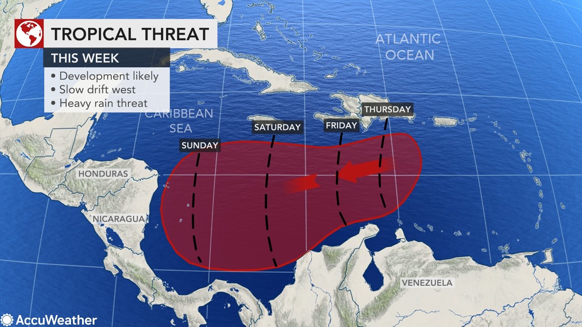
"This feature is likely to become a tropical depression on Friday, a tropical storm this weekend and then perhaps a hurricane during Sunday night or Monday as it moves westward," Kottlowski said.
In the early stages of development, the system will tend to be rather spread out in nature with showers and thunderstorms extending from the northern shores of South America to the large islands of the northern Caribbean.

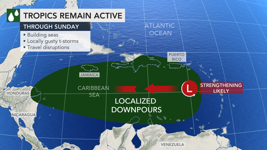
But as the system organizes and strengthens, showers and thunderstorms will become more compact over the western Caribbean this weekend. The disturbed weather could once again expand in areal coverage and intensity as the system nears Central America early next week.
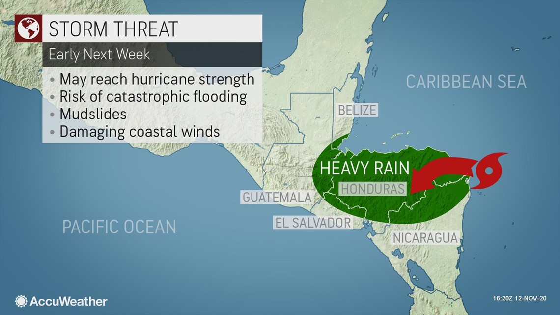
It could take a run at Nicaragua or Honduras as a hurricane, but even a weaker, drenching tropical storm could unleash life-threatening impacts and catastrophic damage in Eta's aftermath. Eta struck Nicaragua as a Category 4 hurricane, ranking among the top five strongest storms to ever hit the nation. The dangerous storm carved a path of destruction through Nicaragua, Honduras and Guatemala, unleashing feet of rain, tremendous flooding and killing more than 100 in early November.
The greatest threat to lives and property from the new cyclone is expected to be dealt by serious flooding caused by feet of rainfall. Major river flooding and flash flooding could occur. The exact track it takes and its strength and forward speed as it plows onshore in Central America will determine how grim the situation will become.

"I do not recall ever seeing back-to-back hurricane strikes in the same general area of Central America, but with the craziness of this hurricane season, we cannot rule that out at this early stage," Kottlowski said.
It is possible the system's path may become erratic as it approaches and moves over Central America, since the winds expected to guide the system along are likely to weaken -- a similar scenario to what unfolded as Eta neared the region in early November.
Weak steering winds caused a similar effect back when Hurricane Mitch slammed the area in late October and early November of 1998. Mitch peaked as a Category 5 hurricane, packing maximum sustained winds of 180 mph (290 km/h), over the western Caribbean, but it weakened to a Category 1 hurricane with 80-mph (130-km/h) winds prior to landfall in Honduras. Mitch unloaded up to 50 inches (1250 mm) of rain and caused disastrous flooding that took the lives of more than 11,000 people in Central America.
If it strengthens into the next tropical storm of the 2020 Atlantic hurricane season, it will be named Iota, the next letter in the Greek alphabet.


2020 set the record for the most tropical storms to be named in one Atlantic hurricane season as Theta became the 29th tropical storm of the season earlier this week.
And the Caribbean threat wasn't the only feature keeping forecasters busy. Eta was racing across northeastern Florida during the mid-morning hours after it made landfall near Cedar Key, Florida, around 4:20 a.m. EST on Thursday. Maximum sustained winds were 45 mph at 10 a.m.
Eta is forecast to move out to sea by Thursday afternoon, where it could become better organized again over the warm waters of the Gulf Stream over the next day or two. Sea-surface temperatures were hovering around 80 F where the storm was in that region of the basin. However, as it moves along, Eta is likely encounter factors, including disruptive winds and colder water in the North Atlantic, that cause the system's eventual demise.
Meanwhile, Tropical Storm Theta continued to swirl south of the Azores on Thursday.
The storm may dip southeastward toward the Canary Islands before it takes a northeastward turn. It is likely to fluctuate in strength but with an overall weakening trend forecast. Some wind and rain could remain intact, eventually affecting part of western Europe later this month.